Pixel Power
Why it's important for Palestinian fighting for Pixel Power in the context of the apartheid from Israel to Palestine?

Literature Table
Synopsis
Many scholars argue that the role of images has long been more than a reflection of objects and a record of events, and that with the popularisation of smartphones, the internet and social media, images are becoming a central means of accessing information and understanding things. The image as a product is inevitably manipulable, and on this basis many questions are raised: how to manipulate it? At what step of the process? To what extent can it be manipulated? Why is it manipulated? What are the possible effects? And so on. In order to answer these questions, various perspectives have been introduced into the study of images, such as Relational Photography, Computational photography, Visual sociology, Digital Hermeneutics, Cognitive Vision Studies and Visual Politic, to demonstrate the impact of images on human behaviour and cognition. In this essay, I focus on the interpretation of images after they have been produced, using pixels from satellite maps of the Palestinian region, and investigate the transformation of information by images and the influence of human sensations on the perception of images. Eventually arguing and highlighting the influence as well as the importance of pixel power in anit-apartheid process, showing that Pixelation can be used as a tool to generate violence.
Pixel Satellite Map Palestine Aparthield Perception
Characteristic of Image
The word "Image" appeared to mean "piece of statuary; artificial representation that looks like a person or thing" in 13C, then "reflection in a mirror" in early 14c [1], when long before photography was invented. It was not until 1958, with the rise of advertising and the topic of social relations, that the concept of the 'public impression' was incorporated. Today, images are widely regarded by scholars as the most powerful way for humans to communicate information and concepts, as Children's Hospital Boston's research suggests "Human Brain Can Recognize Objects Much Faster Than Some Have Thought" [2], they can not only help improve our comprehension by reinforcing information provided in the text, but also allow us to recognise things more easily. However, some scholars argue that the representativeness and objectivity of images as a primary means of recording and responding to the visible world is easily amplified while ignoring the limitations imposed by the technology itself.
Unlike the material world, which can be deconstructed almost infinitely, the image is the capture of light and its mapping onto different scales in pixels, the pixel being the smallest unit of the image, carrying only a single colour and presenting an enlargement or reduction of the photographed object, which is a kind of processed reproduction, and therefore the image is not a perfect reproduction but a limited record that needs to be interpreted.
Interpretation of Image
Hito Steyerl, in her seminal work on Proxy Politics: Signal and Noise [4] in 2014, divided the interpretation of images into two camps: one of engaging with the process of image generation, such as using techniques like computational photography or relational photography, where 'noise' and 'information' are predefined by a particular person, determining what the camera can see. This interpretation of the image is based on the decisions of the individual, organisation, institution or government that makes the censorship, and is a top-down output of information that is clearly purposeful and directed. The other is the personal interpretation of the information conveyed in the image after it has been created, a bottom-up approach that is the dominant mode of information receiving in people's lives. ‘socially organized ways of seeing and understanding events that are answerable to the distinctive interests of a particular social group’. [5]
Information conversion
Under the influence of digitalisation, images have gradually taken on the function of 'seeing', becoming the primary means of perceiving the world, and acquiring information and knowledge. In the process of seeing, the observer is often influenced by various factors, such as the content of the image, its size, resolution, the profession of the photographer, educational background, position, opinion and the attitude and thoughts of the viewer, etc. It is difficult to form a fixed and uniform interpretation, and is, therefore, more subjective, or in other words, more manipulable (this also includes the perception of modifying the content of the image to manipulate the information). In terms of information transformation, the image compresses the three-dimensional world into a two-dimensional space, taking a moment out of the continuum of time and producing a product, which is a single image, that not only blurs the depth and width of space, but also limits the perspective from which one can observe things [6]. For instance, the observer of the image does not directly observe what is pictured in the image, but follows the image maker's and thus the degree of 'visibility' varies, the quality of seeing is differentiated, and there is the possibility of politics and fakery [7]. In the analysis of the image itself, the minimum threshold of detectability depends on the size of the pixels: the smaller the pixels, the more complete and specific the information that can be captured in the image, and conversely, the larger the pixels, the more difficult it is to interpret the image (Figure1). The manipulation of image resolution is therefore not only affecting visual comfort, but also the information carried by the image, a problem that is particularly acute in the case of satellite images of the Palestine-Israel region.
Figure 1. Pixel comparison from 15cm per pixel to 10m per pixel
Pixelation in West Bank on satellite map
Until 2020, satellite maps of the Israel and Palestine region tend to be heavily pixelated, covered up, or even erased in some places, In contrast to the rest of the Middle East and North Africa, images of Palestine-Israel deliberately have the lowest resolution [7]. on platforms such as Google Earth, Bing map, Yandex and Govmap (which is maintained by the Israeli Mapping Centre within the Israeli government as the “national public map” of Israel). With more than 2m per pixel while 0.5m in other places.. Although the legislation was implemented under the pretence of protecting Israel’s national security, it is better characterized as an act of censorship [8]. This pixelation of satellite maps is a recurring issue in Israel’s apartheid policy against Palestine. Due to restrictions imposed by a 1996 US rule known as the Kyl-Bingaman Amendment (KBA) [9], the quality and availability of high-resolution satellite imagery generated by US businesses covering Israel’s occupied Palestinian and Syrian territories have been substantially reduced. As a result, the KBA hinders the work of archaeologists, environmentalists, geographers, and humanitarians. It poses serious obstacles, not only for the preservation of cultural heritage, but also for holding Israel to account for land grabs, home demolitions, and settlement activity.
After the 2020 changes to the KBA, satellite maps provided by US commercial companies have been finally de-pixelated after nearly 25 years, however, progress on the high-resolution of satellite maps of the Palestine-Israel region is still very slow and the resolution of the Israel region is much lower than other regions, with some locations consistently masked or erased in Govmap (from Israel) and Geomolg.ps (from Palestine) has always maintained the masking or erasure of some locations. As Amnon Harari, head of space programmes at Israel’s Defence Ministry said "We would always prefer to be photographed at the lowest resolution possible. It’s always preferable to be seen blurred, rather than precisely." [10], Israel continues to this day to shape its narrative in favour of apartheid through the control of images. Through research at Geomolg.ps and Govmap, there are currently over 43 pixelated areas in the west bank region, which may involve factories, prisons, settlements, outposts and military bases. It is important to note that as pixels are enlarged and visually modified, human actors experience them in isolation from the rest of the picture (Figure 2). This experience gives rise to a virtual reality, in which the pixels simulate a ‘natural’ view of the world [11]. These manipulated sites are often not only in violation of international law but are at the heart of regional conflicts.
 |  |  |
|---|---|---|
 |  |  |
 |  |  |
 |  |  |
 |  |  |
 |  |  |
 |  |  |
 |  |  |
 |  |  |
 |  |  |
 |  |  |
 |  |  |
 |  |  |
 |  |  |
 |  |
Figure 3. Collection of pixelation site in West Bank in 2021
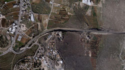
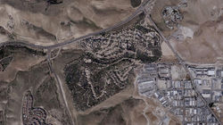
Pixelation near Sebastiya
Take the pixelated area around Sebastiya village as an example, which has been concealed in various ways over the past 25 years, including erasing traces, pixelating, and simply covering it with colour. During an interview conducted on 12 Feb 2022, Zaid al Azhari who is working with the Palestine Heritage Trail stated that this is an Israeli factory that primarily produces cosmetics and aluminium. Over the years, it has produced industrial wastewater that has repeatedly contaminated the farmland of the villagers of Sebastiya. The pollution has caused the death of crops and animals. It also emitted an irritating odour, which negatively impacted the living conditions of the villagers and directly prompted a series of protests. However, the factory on the satellite map is completely obscured (Film 1). The size of the pixel determines the minimum monitorable threshold of the image. It is known from measurements that 15cm/pixel can record the existence of people, 40cm/pixel can record vehicles, houses, constructions and spatial relationships, while when the image is modified to 10m/pixel, it can only express the colours that the algorithm calculates to best represent the 100 square metres. This means that large blocks of pixels would disregard information smaller than the scale of the houses, obscuring all traces of industrial materials, transportation vehicles, sewage tanks, and workers. Additionally, the pixels obscure the distinction between the factory and the regular settlement house, erasing its functional properties from the image entirely. When extracting the two images before and after the pixelation of the same area satellite map, It is 107,133 pixels vs. 159 pixels, with 106,974 pixels of information lost (Figure 3), while there may be factory buildings, machinery, tools and materials, there may be workers, soldiers, tourists, there may be a violent demolition, a sewage dump, a site up for grabs, there may even be a narrative, a part of history, a culture. By holding the power of pixelation, Israel can decide what to show and what not to show, thus constructing its own narrative within a policy of apartheid that could affect the public perception of the site while dividing up Palestinian land.
Film 1. Research film about the Israeli factory near Sebastiya
 |  |
|---|
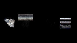
Figure 4. Distracting the images and make a comparison for explore how much information was lost during the pixelation.
Differences between image and reality, the representational function of image
The low-resolution processing of urban-scale satellite maps makes it easy to overlook those pixelated areas and consider them as natural landscapes. In this way, I would argue that the Israeli government manipulates the public perception of many places, concealing the expansion of settlements, the construction of prisons or the existence of factories, giving a misleading sense of the extent of construction, boundaries and types of functions. In this case, while the gap between the image and the real world gradually widens, images and visual artefacts still play an increasingly crucial role in depicting and shaping the world we live in [12]. This also results in images transcending their original ability to reflect objective reality and becoming a means of representing things, but in fact, it is a misunderstanding that cameras are tools of representation; they are at present tools of disappearance. The more people are represented the less is left of them in reality [13]. It is the representation of images that is used to define the state of things, which means these disappearances of illegal construction, although not visible to the public, is in fact a gradual occupation of Palestinian land. To phrase it more dramatically: A growing number of unmoored and floating images corresponds to a growing number of disenfranchized, invisible, or even disappeared and missing people. [14]
Interpretation of images from the pespective of personal sensation
A number of texts on the subject of image quality and politics support these claims that the interpretation of images in terms of human sensation also demonstrates the importance of image resolution and the significant impact of pixelation power, in particular, 'Pixel politics and satellite interpretation in the Syrian war' by Fiona A Greenland [15]. She argues that people's prior sense of images is influenced by their own context and environment and that the body is the bridge between external information and internal sensations.
As a result, people will subjectively sift through the images before they perceive what they are representing, interpreting what is more in line with their own knowledge, position or emotional requirements and ignoring the rest of the evidence, sometimes even creating false perceptions or deliberately drawing inferences that are contrary to the facts. As in The David Irving Trial, which unfolded at the English High Court of Justice between January and April 2000, David Irving denied that a massacre had taken place in the gas chambers of a concentration camp. Instead of gas holes, he interpreted four holes in a photograph of the camp roof taken by a US reconnaissance mission on 25 August 1944 as "brush strokes", because the exact shape of the holes could not be identified at low resolution so it is not possible to prove in the image that the building had a channel for the release of poison gas [17]. This filtering based on people's perceptions is the primary means of analysing low-resolution images or things that are smaller than the threshold of detectability, blurring the line between fact and fiction and greatly increasing the difficulty of forensics and investigation of many crimes, whether in Syria, Afghanistan, or the Palestinian-Israeli region.
Conclusion
Images can be purposefully manipulated and inevitably interpreted in a variety of ways in the process of their actual production, dissemination and reception. However, since images themselves often considered to be objective representations of things, they can block the direct understanding of things and make people think that the interpretation of images is the same as the interpretation of the objects they represent, which gradually becomes a description and redefinition of things and eventually replaces the original reality of things. By which I would argue that the control of the image can influence the perception of what the image represents.
By analysing the case of pixelation in the Palestinian satellite map, it can be seen that pixel power can be used as a political tool, either to inflict violence or protection, while on the one hand, it can cover up illegal factories, prisons, settlements, and even signs of demolitions as "non-existent" in order to evade international law, while on the other hand, it can make many Palestinian facilities, roads and even villages "non-existent" in order to silently contest their land. Whether by intervening in the image production process to control the content of the image display or by masking and modifying the image content during the display process, it is a re-definition of the content of the image rather than a pure reflection of reality, especially in the case of online satellite images, where a few millimetres of the screen may correspond to an outpost or even an entire military base in real space. This level of manipulation is enough to influence people's guesses about function, activity, and can even be evidence of the existence of certain events. It is for this reason that I perceive the pixel as an instrument of violence that has long affected the land and lives of Palestinians, by which the Israeli occupation of images conceals crimes, affects people's perception of the boundaries of villages and cities, and the extent of the massive pixelation makes the occupation of Palestinian land invisible. I would claim that pixel power is in fact part of Israel's apartheid policy towards Palestine, and that the Palestinians need to fight for this power as well. Counteract the spatial oppression and disappearance of images.
Bibliography
Etymonline.com. 2022. image | Search Online Etymology Dictionary. [online] Available at: <https://www.etymonline.com/search?q=image> [Accessed 15 July 2022].
Children's Hospital Boston. 2009. Human Brain Can Recognize Objects Much Faster Than Some Have Thought. [online] Available at: <https://www.sciencedaily.com/releases/2009/04/090429132231.htm> [Accessed 17 July 2022].
Greenland, F. A. (2022) ‘Pixel politics and satellite interpretation in the Syrian war’, Media, Culture & Society. doi: 10.1177/01634437221077169.
Steyerl, H., 2014. Proxy Politics: Signal and Noise - Journal #60 December 2014 - e-flux. [online] E-flux.com. Available at: <https://www.e-flux.com/journal/60/61045/proxy-politics-signal-and-noise/> [Accessed 19 May 2022].
Goodwin, C., 1994. Professional vision. 3rd ed. pp.606-633.
Agha, Z., 2018. Satellite Imagery and the Palestine-Israel Exception. [online] Al-Shabaka. Available at: <https://al-shabaka.org/commentaries/satellite-imagery-and-the-palestine-israel-exception/> [Accessed 10 July 2022].
Agha, Z., 2020. Israel Can’t Hide Evidence of Its Occupation Anymore. [online] Foreign Policy. Available at: <https://foreignpolicy.com/2020/08/03/israel-cant-hide-evidence-of-its-occupation-anymore/> [Accessed 1 November 2021].
2022. [online] Available at: <https://www.reuters.com/article/uk-israel-usa-satellites-idUKKBN2470VE> [Accessed 6 July 2020].
Bleiker, R., 2018. The Power of Images in Global Politics. [online] E-International Relations. Available at: <https://www.e-ir.info/2018/03/08/the-power-of-images-in-global-politics/> [Accessed 9 May 2022].
Steyerl, H., 2012. The Spam of the Earth: Withdrawal from Representation - Journal #32 February 2012 - e-flux. [online] E-flux.com. Available at: <https://www.e-flux.com/journal/32/68260/the-spam-of-the-earth-withdrawal-from-representation/> [Accessed 1 May 2022].
Weizman, E., 2015. Violence at the Threshold of Detectability - Journal #64 April 2015 - e-flux. [online] E-flux.com. Available at: <https://www.e-flux.com/journal/64/60861/violence-at-the-threshold-of-detectability/> [Accessed 15 June 2022].
Research film
Produced by Jack Liu, 2022
全部影片
Reflective Appendix
I believe that images can not only influence perceptions, but can even shape and modify them. As images have become one of the primary sources of information and are far more efficient than words in accessing information, it can be argued to some extent that most people's knowledge is derived from the impressions of countless images. Although the manipulability of images is well known, the influence of the internet has resulted in hundreds of millions of images being generated, modified and re-generated every day, making it impossible for people to trace the origins of every image they see, especially for new knowledge, and to identify the authenticity of the information they have acquired. With the accumulation of information and the lack of ability to disprove it, varied information is combined to shape people's perceptions of things, making it very easy to be misled, deceived and even manipulated when images are manipulated purposefully.
In the case of Sebastiya, for example, the factories built by Israel have been covered up for so long that their existence has remained unknown to the villagers for so long that no one can even know what is inside. In contrast, however, the sewage problems caused by the factories actually undermine the security of the Sebastiya land and restrict the mobility of the villagers. In terms of the local Palestinian resistance to this occupation, the pixel, which is scattered throughout the area, makes this illegal site disappear, not only in image but also in consciousness, and this disappearance turns a widespread problem into a specific conflict, transforming the policy of apartheid into a 'conflict of the inhabitants' in a particular area, making it extremely difficult for institutions or individuals to This has been a major obstacle to institutional or individual investigation and evidence gathering. In the specific case of Sebastiya village, the presence of the factory interferes with the scope of development and construction in the village, the boundaries between areas A/B/C are blurred by pixelated areas, and illegal construction becomes a space that is not publicly known but actually exists, exacerbating the expansion of Israeli occupation.